
Rainbow Mountain Day Trip Guide
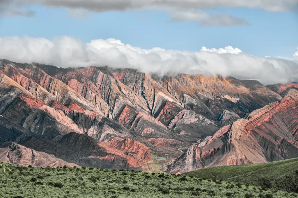
Argentina’s answer to Rainbow Mountain rises east of Humahuaca in Jujuy. Properly known as Serranía de Hornocal or Cerro de los 14 Colores, this multicolored mountain range is reached by a high, unpaved road rather than a long summit hike. The panorama is the reward, but the journey requires sensible planning around altitude, transport, weather, and current access conditions.
- Use Humahuaca as the base for the trip. The viewpoint is about 25 kilometres east of town and roughly one hour away by road.
- Expect a winding dirt and gravel road that climbs from around 2,900 metres to approximately 4,350 metres above sea level.
- Choose an organized excursion or arrange suitable transport with a driver comfortable on high mountain roads.
- Treat 11:30 to 18:00 as recommended viewing guidance, not guaranteed opening hours.
- Confirm the community entrance fee, road status, and same-day access locally before departure.
- Take the altitude seriously even though the main attraction is a vehicle-accessed viewpoint rather than a summit trek.
The name matters when planning. The internationally famous Rainbow Mountain is Vinicunca in Peru, but this Argentina guide covers Serranía de Hornocal near Humahuaca. National tourism information calls Hornocal the “fourteen-colour mountain” and presents it as an excursion from the historic Andean town.
Hornocal works best as a half-day scenic outing for travelers already exploring Quebrada de Humahuaca. It suits visitors who want a dramatic mountain panorama without committing to a long trek. The main limitation is not walking distance. It is the combination of a rough approach road and a viewpoint standing about 4,350 metres above sea level.
Why Argentina’s Rainbow Mountain is called Hornocal
Serranía de Hornocal is the destination’s geographic name, while Cerro de los 14 Colores describes the colorful mountain seen from the viewpoint. Using both names helps avoid confusion when asking for transport, checking access, or searching for a tour in Humahuaca.
The excursion is closely tied to Humahuaca, the practical departure point for the road east. Travelers putting together a longer regional route can place the outing within broader Chile and Argentina destination planning, but Hornocal itself is firmly in Jujuy Province in northwestern Argentina.
The attraction is a broad panorama of the multicolored range. Visitors arrive near the viewpoint by vehicle, pay a community entrance charge, and continue to a parking area or explanade overlooking the mountains. This arrangement makes the view physically closer than many high Andean attractions, although the altitude still demands respect.
What the Hornocal day trip is really like
A Hornocal day trip is primarily a mountain-road excursion followed by time at a scenic viewpoint. It should not be planned as a conventional hiking day or summit attempt. Most of the effort lies in managing the drive, the rapid elevation gain, and the effects of standing at very high altitude.
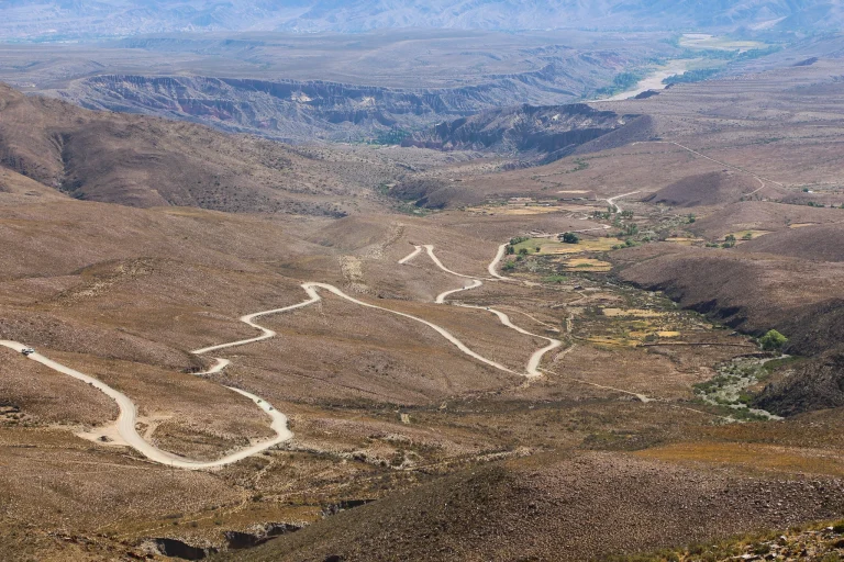
The road rises from about 2,900 metres to 4,350 metres over a relatively short distance. Its curves, dirt surface, and mountain setting make the trip feel much more substantial than its roughly 25-kilometre distance suggests. Official guidance estimates about one hour of driving in each direction from Humahuaca.
At the top, the parking area and explanade provide the principal view. Do not mistake vehicle access for low-altitude ease. Walking slowly, avoiding unnecessary exertion, and keeping the visit flexible are sensible responses to the elevation.
The viewpoint is managed by 10 families from Hornocal’s Indigenous Omaguaca community. The entrance payment supports access to a place managed at the community level, adding a local dimension to what can otherwise look like a simple scenic stop.
Getting to Serranía de Hornocal from Humahuaca
The viewpoint lies about 25 kilometres east of Humahuaca along Provincial Route 73. Allow roughly one hour for each direction, while recognizing that weather and road conditions can affect the pace. The mountain road is unpaved, winding, and subject to a steep elevation gain.
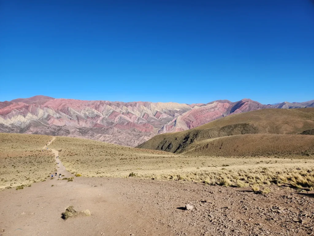
Humahuaca is therefore the most practical base. Starting there keeps the excursion focused and avoids combining the final mountain road with an unnecessarily long approach on the same day. Confirm the road condition and access arrangements in town before committing to the climb.
Independent drivers should be comfortable with gravel, curves, steep terrain, and limited room for distraction. During the rainy period from December through March, the dirt road can become slippery. Wild and domestic animals can also be loose beside the route, so a cautious speed is essential.
Do not assume that an ordinary road distance means an ordinary drive. Vehicle suitability, driver confidence, weather, and recent road conditions matter more here than saving a small amount of time. A guided option or local driver is the simpler choice for anyone uneasy about the route.
Tour or independent transport: which option fits best?
| Option | Best for | Main consideration |
|---|---|---|
| Organized excursion | Travelers who prefer not to drive the mountain road | Pickup points, duration, group size, and inclusions depend on the selected tour. |
| Arranged local driver | Visitors seeking a direct trip without self-driving | Agree on the departure plan, waiting time, return, and fee before leaving. |
| Independent vehicle | Experienced drivers comfortable with unpaved high-altitude roads | You are responsible for vehicle suitability, road checks, weather decisions, and the return drive. |
A tour removes the strain of navigating the road and lets every traveler concentrate on the scenery. Some local excursions are marketed as trips of roughly four hours, but exact duration varies with the itinerary, departure point, group, and conditions. Check the booking details rather than treating that estimate as a fixed schedule.
An arranged driver offers similar relief from the road while giving a private party more control over timing. Before leaving, make sure the plan covers transport to the community entrance, waiting at the viewpoint, and the return to Humahuaca.
Self-driving gives the greatest independence, but it also places every road decision in your hands. No regular public transport schedule should be assumed for the viewpoint. Travelers relying on shared transport should check locally in Humahuaca before building the day around it.
Choosing the best time for the mountain views
Jujuy tourism guidance recommends viewing Hornocal between 11:30 and 18:00. Use that period to shape the outing around later daylight rather than assuming a dawn departure from Humahuaca is necessary.
That recommendation is a viewing window, not a promise that the community entrance operates throughout those hours. Access schedules can change, so confirm same-day conditions locally before departure. This single check can prevent a long climb toward a closed or weather-affected road.
Season matters most for the road. From December through March, rain can make the dirt surface slippery. If conditions are poor, delaying or skipping the excursion is a better decision than treating the viewpoint as an essential stop at any cost.
Outside the rainy period, a same-day road check still makes sense because mountain conditions can change. Keep enough flexibility in the itinerary to move Hornocal to another suitable day if local advice points to difficult access.
Planning for 4,350 metres of altitude
The Hornocal viewpoint sits at approximately 4,350 metres above sea level. That is substantial altitude exposure, even for visitors who plan to remain close to the vehicle. The road also gains roughly 1,450 metres from its lower starting elevation, so the change happens quickly.
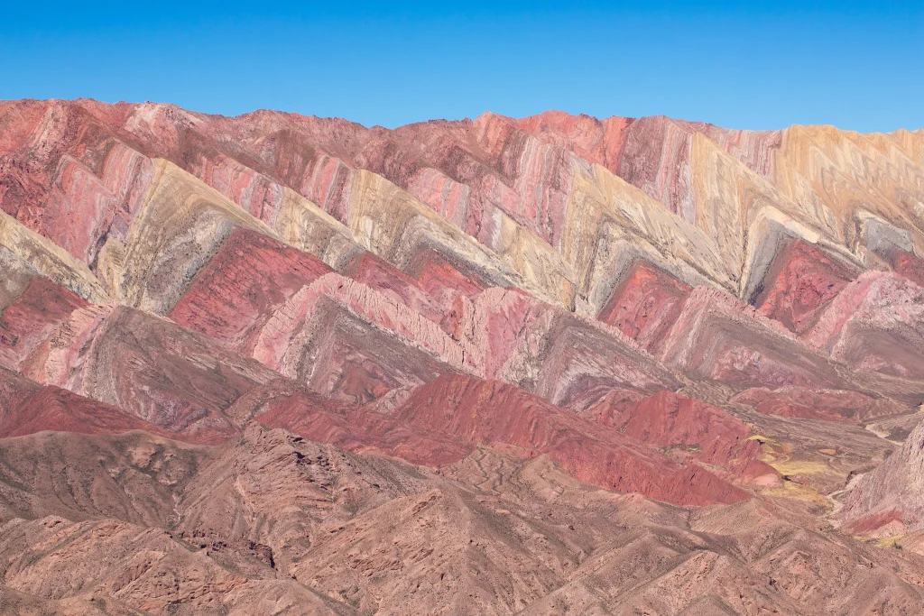

Build the excursion conservatively. Move slowly at the viewpoint, avoid turning the stop into an athletic challenge, and tell the driver or guide promptly if you feel unwell. Returning to a lower elevation is more important than extending the visit for another photograph.
Travelers unfamiliar with high elevations can consult a plain-English guide to altitude and acclimatisation in the Andes before finalizing the day. Understanding how to pace a high-altitude itinerary is useful because easy vehicle access does not remove the physiological challenge.
Consider scheduling Hornocal after spending some time in the Andean region rather than making it the first major high-altitude stop. This does not guarantee comfort, but it encourages a more measured itinerary and leaves room to reconsider if anyone in the group is struggling with elevation.
Anyone with a health concern affected by high elevation should seek appropriate medical advice before the trip. Tour operators and drivers can explain logistics, but they cannot decide whether substantial altitude exposure is suitable for an individual traveler.
A practical half-day itinerary from Humahuaca
- Confirm the day’s road status, community access, current entrance charge, and departure arrangement in Humahuaca.
- Leave enough time for approximately one hour of driving along Provincial Route 73 without pressuring the driver to rush.
- Plan arrival within the recommended 11:30 to 18:00 viewing period, while following the current access instructions provided locally.
- Pay the community entrance charge and continue to the parking area or explanade near the viewpoint.
- Keep the viewpoint visit gentle and flexible because of the 4,350-metre elevation.
- Allow roughly another hour for the return to Humahuaca, with extra flexibility for road or weather conditions.
This schedule leaves room for a focused outing without pretending that every trip follows the same clock. Organized tours, private drivers, weather, and road conditions all influence the total duration. Avoid placing a tightly timed onward departure immediately after the expected return.
The half-day format also respects the nature of the attraction. Hornocal is about reaching a powerful viewpoint safely, taking in the multicolored range, and descending before altitude or road fatigue begins to dominate the experience.
Entrance fees, facilities, and accessibility
Visitors pay an entrance charge to the Hornocal community before reaching the viewpoint parking area. The current amount is not fixed here because it can change. Confirm the fee and accepted payment method locally before departing Humahuaca.
Parking at the viewpoint is confirmed, but travelers should not interpret that as proof of comprehensive visitor facilities. Plan the trip as a remote mountain outing and ask about any facility that is essential to your group before booking transport.
Do not assume the site is wheelchair-accessible simply because vehicles reach the viewpoint. Travelers requiring a step-free route, accessible toilet, adapted vehicle, or mobility assistance should confirm the relevant arrangements with the community or tour operator.
The altitude is also part of accessibility. A traveler may manage a short distance easily at lower elevations yet find movement more demanding at 4,350 metres. Discuss the pace with the driver or guide and keep the option of remaining close to the vehicle.
Tour inclusions vary, so check the selected package for transport type, pickup point, waiting time, entrance-fee treatment, and return arrangements. One careful review of the confirmation is enough to prevent most misunderstandings.
What to bring for the Hornocal road trip
- Water and a simple snack for the return journey
- Layers suited to the day’s mountain forecast
- Sun protection appropriate for time at high elevation
- Secure, closed footwear for uneven outdoor surfaces
- Any personal medication needed during the excursion
- A charged phone and saved booking or driver details
Pack lightly enough that reaching essentials does not become a chore. Water, sun protection, and an extra layer should remain accessible in the vehicle rather than buried beneath larger luggage.
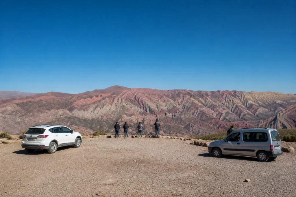
Drivers should prepare for a mountain dirt road rather than an ordinary paved attraction entrance. Check the vehicle, route status, and weather before leaving. No packing list can compensate for an unsuitable vehicle or a driver uncomfortable with the terrain.
Who will enjoy this day trip most?
Hornocal is a strong choice for photographers, scenic-road travelers, and visitors who want a memorable high-Andean panorama without a long summit hike. It also fits naturally into a stay in Humahuaca because the town is the practical departure point.
The trip is less suitable for travelers who react poorly to substantial altitude, require confirmed accessible facilities, or feel uncomfortable on steep unpaved roads. A guided excursion solves the driving issue, but it does not remove the elevation or guarantee formal accessibility.
Families and mixed-ability groups should judge the outing by the needs of the most altitude-sensitive traveler. A shorter viewpoint visit and private transport can provide flexibility, but the decision should still reflect the 4,350-metre setting.
Travelers comparing the region with other first journeys can also consult a guide to the best places to visit in the Andes for first-time visitors. Hornocal belongs on that broader list when striking scenery matters more than extensive on-site infrastructure.
Is the Hornocal day trip worth it?
Hornocal is worth the trip for travelers based in Humahuaca who are comfortable with altitude and prepared for a rough mountain road. Its appeal is direct: a vehicle-accessed viewpoint facing one of northern Argentina’s distinctive multicolored ranges.
The best plan is simple. Choose transport suited to Provincial Route 73, confirm the fee and access locally, aim for the recommended viewing period, and keep the visit gentle at 4,350 metres. With those details settled, the day becomes less about logistics and more about giving Hornocal’s bands of color the time and attention they deserve.
Frequently asked questions
Is Argentina’s Rainbow Mountain the same as Peru’s Rainbow Mountain?
No. This guide covers Serranía de Hornocal, also called Cerro de los 14 Colores, near Humahuaca in Jujuy, Argentina. Peru’s internationally known Rainbow Mountain is Vinicunca.
How far is Hornocal from Humahuaca?
The Hornocal viewpoint is about 25 kilometres east of Humahuaca via Provincial Route 73. Allow roughly one hour each way on the winding dirt and gravel mountain road.
Do you have to hike to Serranía de Hornocal?
No long summit trek is required for the principal panorama. Vehicles reach a parking area or explanade near the viewpoint, although the elevation of approximately 4,350 metres can still make movement demanding.
What is the best time to visit Hornocal?
Jujuy tourism guidance recommends viewing between 11:30 and 18:00. This is viewing advice rather than guaranteed opening hours, so confirm same-day access in Humahuaca before leaving.
How much is the Hornocal entrance fee?
Visitors pay an entrance charge to the Hornocal community, but the amount can change. Confirm the current fee and payment method locally before departure.
Can you drive to Hornocal independently?
Yes, independent transport is an option for drivers comfortable with steep, winding dirt and gravel roads. The route can become slippery during the December-to-March rainy period, and animals may be loose beside the road.
Is Hornocal wheelchair-accessible?
Do not assume full wheelchair accessibility. Parking is available at the viewpoint, but step-free routes, adapted transport, accessible toilets, and other formal facilities should be confirmed before booking.
How high is the Hornocal viewpoint?
The viewpoint is approximately 4,350 metres above sea level. Plan a gentle visit, avoid unnecessary exertion, and return to a lower elevation if anyone feels unwell.
Serranía de Hornocal, Argentina’s Cerro de los 14 Colores, is visited on a high-altitude excursion from Humahuaca by Lucas Leonel Suárez, Pexels.
More bookable experiences
Three tours to compare
Review current provider details before booking. Discover Andes may earn a commission at no extra cost to you.
Continue exploring
More practical guides selected from the Discover Andes library.
Andean Archaeology and Culture Guide
Plan a thoughtful archaeology and culture journey through Argentina’s Quebrada de Humahuaca, Pucará de Tilcara, Coctaca terraces, and…

The Andes Nightlife Guide
Plan an evening in Bariloche with this practical Andes nightlife guide, covering breweries, bars, casino entertainment, conditional disco…

The Andes Winter Travel Guide
Plan an Argentine Andes winter trip around the experience you want: Mendoza’s mix of snow, wine and hot…
The Andes Architecture Guide
Trace the architectural layers of Argentina’s Quebrada de Humahuaca, where pucaras, terraces, Inca-era routes, Spanish-era churches, and living…